How
can
we
help?
Frequently asked questions
What is Urban PERIScOPE?
Urban PERIsCOPE workflow achieves the extension of traditional 2D cadastral maps into data-rich, dynamic 3D repositories, which could be used by authorities and local stakeholders for territorial planning, sustainable built heritage, and “smart city” applications for Cyprus. Urban PERIsCOPE will assist in monitoring of urban growth and the evaluation of rehabilitation plans through an integrated platform that will enable relevant stakeholders to monitor chronological transformation of urban fabric linked with BIM data (morphology, material and structural analytical information) through searchable and visualized representations. More specifically, these data visualisations/ representations will enable stakeholders to reconsider existing practice, reflect on heritage building observed conditions, and may even help stakeholders decide to initiate a discussion about the update of relevant policies to facilitate and support the reactivation of the specific neighbourhood toward a more environmental and resilient development.
To learn more, check out http://uperiscope.cyi.ac.cy/
What information can I find on Urban PERIScOPE?
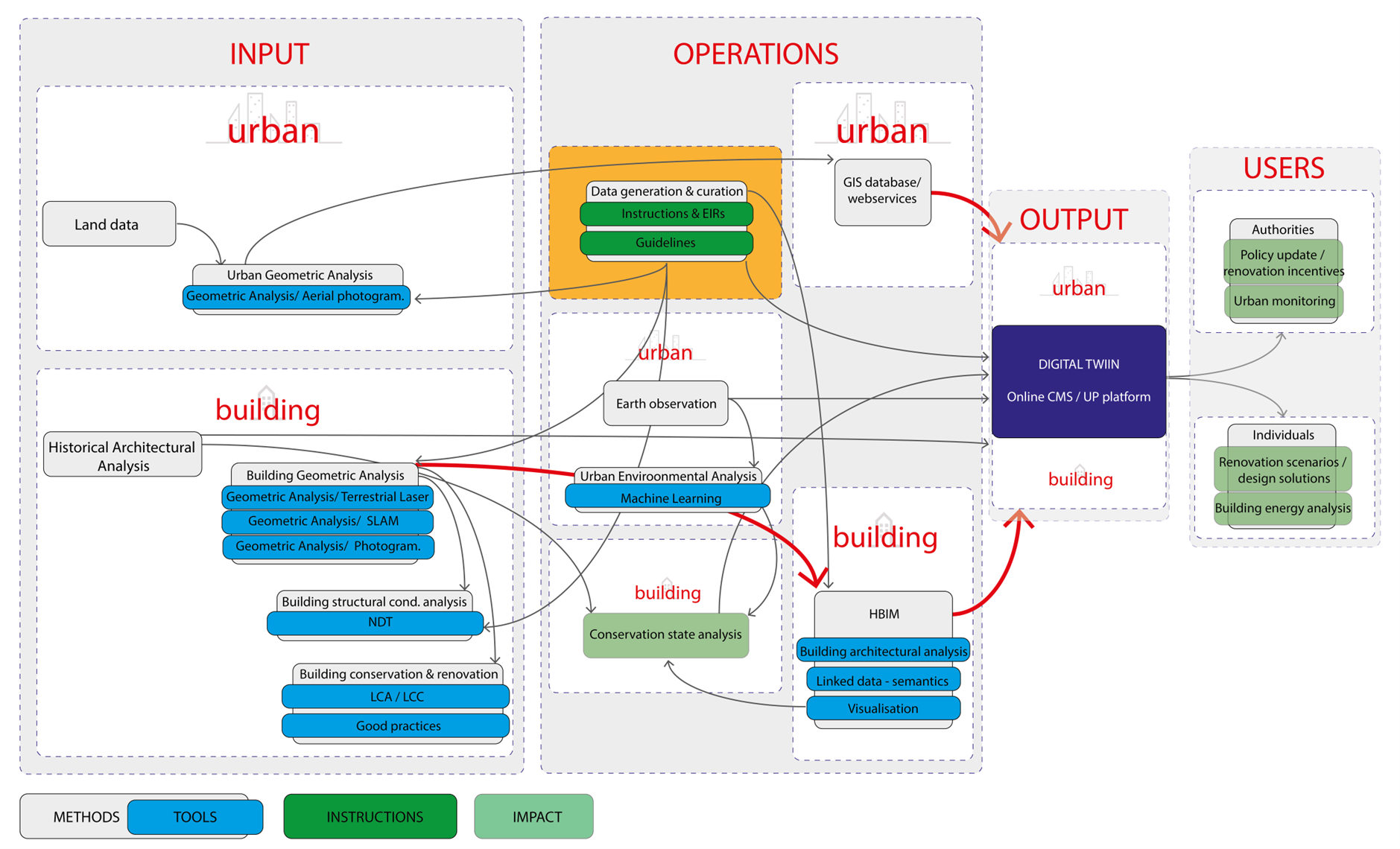
Diagram that illustrates the steps of the Urban PERIScOPE workflow, structured by methods, tools and instructions and illustrating the dataflow between the steps, grouped by scale (urban and building scales).
Scan-to-HBIM
3D documentation techniques are used for reality capturing the structural and geometric complexity of historic clusters and the pilot buildings that become accessible through the online environment of the platform to support conservation state analysis with accurate visualisations. These documentations are carried out in parallel with historical studies (bibliographical, archival, archaeological, etc.), which involve the study of historical layers (present and previous uses) and the assessment of the heritage significance and vulnerability to change. The HBIM-supported online platform allows users to control semantic hierarchies of historic buildings' architectural elements.
Information available on Urban PERIScOPE:
- Cadastral information about buildings;
- GIS webservice;
- Environmental analysis information (e.g., Land Surface Temperature);
- Chronological change basemaps;
- Aerial 3D information at building block and neighborhood scales;
- Historical information of heritage buildings;
- 2D architectural drawings;
- 3D documentation of buildings (existing condition survey);
- Conservation state analysis of heritage buildings;
- BIM representations;
- Structural analysis and thermal condition integration of Non Destructive Testing of material conditions of building “as is”;
- 5D bill of quantities;
- 6D LCA: Life-cycle Assessment results of heritage buildings;
- Life-cycle Costing of heritage buildings;
- Valorisation of built heritage renovation.
What can I use the Urban PERIScOPE for?
Users of the platform can be one of the following categories (each with different access rights):
- public authorities;
- academic researcher, architecture historian, archaeologist;
- professionals: engineer, architect, contractor, developer;
- property owner / interested buyer / existing tenant.
Use case 1: Officer of local authority
An officer of the Department of Antiquities or an engineer of the Municipality is logging in the platform:
- User can explore data of specific building architectural features and respective construction/intervention phases;
- User can check the conservation state of a specific building which is classified as similar to one under threat of demolition;
- Officer studies the current situation of buildings, as the municipality receives too many enquiries and claims from civil engineers and property owners / tenants who are concerned about the structural condition of their property.
Use case 2: Accessing data analytics at urban scale
The user can explore building data visualized by means of georeferenced information about:
- Occupied / renovated / empty buildings;
- Environmental aspects of the neighbourhood (e.g. Urban Heat island), overlaid with chronological transformations;
- Map of land use;
- Cadastral information.
Use case 3: building study
The user can select a specific street and an individual heritage building (of the PERIScOPE pilot heritage buildings) to study through:
- tool-to-tool for visualising and comparing building in the ‘as-is’ status;
- operative tools/methods for building inspection, such as:
- 2D drawings;
- Building phasing;
- Conservation state analysis;
- 3D model;
- Online BIM interactive viewer;
- 360 viewer;
- Virtual Reality (VR) enabled access to photorealistic representation of the building for the user to virtually visit the building under study to acquire deeper knowledge of its condition;
- Database of BIM families of construction assets;
- Material databases;
- Cloud-based services for diffusing knowledge about history and cultural characteristics of architectural heritage and historic neighbourhoods.
Use case 4: good practices
The user has access to the available pool of resources about heritage building valorization, conservation and analysis from up-to-date literature. Resources are structured by theme and purpose of use.
How can I use the Urban PERIScOPE?
The Urban PERIScOPE playbook can be a valuable resource to help you effectively utilize the Urban PERIScOPE platform and make the most out of its features and functionalities. The UP playbook is a comprehensive guide that provides detailed instructions, best practices, and tips for using the platform to its full potential.
The playbook includes step-by-step tutorials on how to navigate the platform, search for building data, access curated documents, explore environmental data, and collaborate with other users. It also contains user guides for specific tools and functionalities, such as the 3D viewer, metadata management, and data export options.
The UP playbook can help you in the following ways:
1. Getting Started: It provides an overview of the platform's purpose, features, and navigation, allowing you to quickly familiarize yourself with its layout and capabilities.
2. Guided Exploration: The playbook offers guided exploration of various sections and functionalities, helping you to effectively use the platform for specific tasks or research purposes.
3. Optimizing Usage: It shares best practices and tips to optimize your usage of the platform, enabling you to efficiently access and analyze building data, environmental information, and curated documents.
4. Collaboration: The playbook outlines how to collaborate with other users, participate in discussions, and share insights, fostering an active and engaged community of platform users.
5. Troubleshooting: In case of any issues or questions, the playbook includes troubleshooting tips and FAQs, helping you overcome common challenges.
6. Stay Updated: The playbook may also provide information on updates, new features, and improvements to the platform, allowing you to stay up-to-date with the latest enhancements.
To access the UP playbook, click on the image on the left.
How can I access / Download building data?
To access or download building data from the Urban PERIScOPE platform, follow these steps:
1. Navigate to the Building Data: Go to the "Search" section where building data is available. You can use the top menu to navigate to different sections of the platform.
2. Filter and Search: Use keywords or selected metadata lists to filter the building datasets according to your specific criteria. You can also sort the results by name, newest entry, or featured entry.
3. Access Building Details: Click on a specific building thumbnail from the list of results to view the building details page. This page contains information about the building, including title, description, metadata, image gallery, attached files, and 3D representations.
4. Download Files: On the building details page, you may find attached files, such as documents, reports, images, or 3D models. To download these files, click on the respective links or buttons provided.
5. Follow Data Access Policies: Ensure that you comply with any data access policies or copyright restrictions when downloading building data from the platform.
6. Collaboration and Contribution: If you have editing permissions, you may also contribute additional data or information to the building dataset, collaborate with other users, and share insights related to the building.
How can I upload my data on Urban PERIScOPE?
The Urban PERIScOPE platform operates as a by-invitation system, requiring users to request access from the administrator to obtain an editing account. If you wish to contribute to the platform, access datasets, or collaborate on heritage building information, kindly contact the platform administrator to request an editing account. The administrator will review your request and grant access based on your role and permissions within the system. This approach ensures data security, privacy, and controlled access to the valuable resources available on the platform. Feel free to reach out to the platform administrator to initiate the process and start exploring and contributing to the wealth of heritage building information available within the Urban PERIScOPE platform.
In the meantime download the UP back-end UserGuide
An innovative platform for the identification, classification, documentation and renovation of heritage buildings.
Legal
Terms of Use© 2022. All rights reserved